
What Is an Aquifer?
Table of Contents
Turn on a tap in most cities and there’s a fair chance the water travelled through rock or sediment before it ever reached a pipe. Roughly half the world’s population depends on groundwater for some or all of its drinking water, and that water almost always comes from an aquifer. Yet most people, including a lot of engineering students, have a fuzzy idea of what an aquifer actually is — often picturing an underground lake or river. It isn’t that. Understanding what an aquifer really is, and how it behaves, matters for anything from well design to urban planning to why a valley’s ground can slowly sink.
How Do Aquifers Work? A Simple Explanation
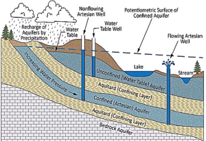
An aquifer is a body of rock or unconsolidated sediment — sand, gravel, sandstone, fractured limestone, fractured basalt — that is both saturated with water and permeable enough to transmit that water in usable quantities to a well or spring. The U.S. Geological Survey defines it as “an underground body of porous materials, such as sand, gravel, or fractured rock, filled with water and capable of supplying useful quantities of water to a well or spring”.
Two properties decide whether a formation qualifies as an aquifer rather than just “wet ground”:
Porosity — the percentage of a rock or soil’s volume that is empty space. Loose, well-sorted sand can have porosity above 30%; solid granite has almost none unless it’s fractured.
Permeability (expressed for water as hydraulic conductivity) — how easily water can actually move through those pore spaces. A clay layer can have high porosity but very low permeability, because its pores are tiny and poorly connected, so water barely moves through it even though a lot of water is stored in it.
An aquifer needs both: enough interconnected void space to hold water, and enough permeability to let that water flow toward a well or a stream at a rate that’s actually useful. Picture a giant, slightly compressed sponge buried underground, not an open cavern — that mental image is closer to reality than “underground lake” and matters for how wells, recharge, and contamination all behave.
Aquifer vs Groundwater: What Is the Difference?
The two terms get used interchangeably in casual conversation, but they refer to different things, and mixing them up leads to sloppy thinking about how groundwater systems actually behave.
Groundwater is the water itself — the water occupying the pore spaces and fractures below the water table.
An aquifer is the geologic material that stores and transmits that water — the sand, gravel, or fractured rock.
The distinction matters practically. A rock layer can be present everywhere in a region, but only part of it may function as an aquifer if the rest is unsaturated, or if its permeability is too low to yield water at a usable rate. Groundwater, meanwhile, can exist even in materials that aren’t classified as aquifers — a clay layer holds groundwater, but because it releases that water so slowly, hydrogeologists usually classify it as an aquitard rather than an aquifer.
Types of Aquifers: Confined, Unconfined, Perched, and Artesian
Not all aquifers behave the same way, and classifying them correctly is the first step in any groundwater investigation, well design, or contamination-vulnerability assessment.
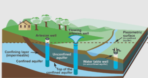
Unconfined (water-table) aquifer. The USGS defines this as “an aquifer whose upper water surface (water table) is at atmospheric pressure, and thus is able to rise and fall”. It has no impermeable layer directly above it — just unsaturated soil and rock connecting it to the surface. Because it’s the shallowest type, it responds fastest to rainfall, drought, and pumping, which also makes it the most vulnerable to surface contamination.
Confined aquifer. This is sandwiched between two layers of low-permeability material (aquitards or aquicludes), which puts the water under pressure. The USGS notes that in a confined aquifer, “when the aquifer is penetrated by a well, the water will rise above the top of the aquifer” — because the confining layers trap the water at pressure greater than atmospheric. Confined aquifers are typically deeper, better protected from surface contamination, and slower to recharge, since water has to work its way in from a recharge area that may be a considerable distance away.
Artesian aquifer. This is really a special case of a confined aquifer, not a separate type by origin. The USGS defines it as a well “in which the water will rise above the top of the aquifer. When the water level is above land surface, water will flow from the well” without pumping. Whether a confined aquifer produces a flowing artesian well or just a well where water rises partway up the casing depends on the local pressure head relative to the land surface elevation.
Perched aquifer. A perched aquifer forms above the regional water table, separated from the main aquifer by an unsaturated zone. It develops where “percolating recharge is slowed to the extent that it saturates the porous material above” a localized lens of low-permeability material, such as a clay layer, within the unsaturated zone. These systems are often small, seasonal, and easily depleted, which makes them an unreliable water source even though they’re frequently the shallowest — and therefore first — water a well driller hits.
What Is an Aquifer Recharge Zone?
A recharge zone (or recharge area) is the part of the landscape where water actually enters an aquifer — typically where the aquifer’s permeable material is exposed at or near the surface, or where a river or lake sits directly above it and loses water downward into the ground.
Hydrogeologists generally distinguish two recharge mechanisms. Diffuse recharge happens when precipitation infiltrates fairly uniformly through soil over a broad area. Focused recharge happens at specific points — a losing stream, a lake bed, a sinkhole — where much more water enters over a small footprint. Which mechanism dominates depends heavily on climate and geology: focused recharge tends to matter more in arid regions, where dry soil limits diffuse infiltration.
This is why recharge zones deserve protection in land-use planning. Paving over a recharge zone, or contaminating it with poorly managed runoff, doesn’t just affect that patch of ground — it can degrade water quality or reduce water availability for an aquifer that may supply wells kilometers away. The EPA notes that engineered aquifer recharge — deliberately routing water into the ground via spreading basins, infiltration pits, or injection wells — is also used as a management tool, both to replenish depleted aquifers and to prevent problems like saltwater intrusion in coastal aquifers and land subsidence in over-pumped ones.
What Is the Water Table and How Does It Work?
The water table is the upper surface of the saturated zone in an unconfined aquifer — the boundary below which every pore and fracture is full of water, and above which pores contain a mix of air and water (the “unsaturated” or “vadose” zone). The USGS defines it simply as “the top of the water surface in the saturated zone of an unconfined aquifer”.
The water table is not flat, and it’s not static. It generally mimics a subdued version of the surface topography, sitting higher under hills and closer to the surface near streams and wetlands, because groundwater flows from areas of higher hydraulic head toward areas of lower head — ultimately discharging into rivers, lakes, springs, or the ocean. It also moves up and down seasonally: it rises after recharge events like monsoon rainfall or snowmelt, and it falls during dry periods or when pumping draws water out faster than it’s replenished.
This is why a shallow domestic well that works fine in September can run dry in April, and why a citizen-science monitoring project in Kathmandu Valley — where 72 community volunteers tracked groundwater depths monthly from 2020 to 2024 — recorded water tables ranging from as shallow as 0.13 meters to as deep as 16.18 meters below ground level, with the shallowest readings consistently occurring during the June–September monsoon and the deepest during the dry winter months. The same study found groundwater levels were generally deeper in the densely urbanized central valley than in the peri-urban periphery, a pattern the researchers attributed to concentrated extraction and reduced infiltration from paved surfaces.
Aquifer vs Aquitard vs Aquiclude vs Aquifuge
These four terms describe a spectrum of how well a geologic unit stores and transmits water, and getting them straight matters for reading a hydrogeological cross-section correctly.
- Aquifer — stores and transmits water in economically usable quantities; high hydraulic conductivity. Examples: sand, gravel, fractured sandstone, fractured or karstic limestone.
- Aquitard — has some storage capacity but transmits water slowly; for practical purposes, not enough to supply a well directly, though it can leak water into an adjacent aquifer over time. Examples: silt, clay, shale.
- Aquiclude — stores water but transmits essentially none in a practically usable sense; functions as a barrier to flow.
- Aquifuge — neither stores nor transmits water at all; completely impermeable. True aquifuges are rare in practice — dense, unweathered, unfractured igneous or metamorphic rock is the classic example — and the term has largely fallen out of everyday use in the field.
One caveat worth keeping in mind: these categories are relative, not absolute. The same layer of fine sand might function as an aquifer where it sits next to silt, but behave more like an aquitard where it sits next to clean gravel. Hydrogeologists classify a unit based on its permeability contrast with its neighbors and on whether it can yield water fast enough for the intended use, not on a fixed permeability threshold.
How Long Does It Take to Replenish an Aquifer?
This is where a lot of public understanding goes wrong, because “groundwater” often gets treated as automatically renewable, when in practice recharge timescales vary from years to millennia depending on the aquifer.
Shallow, unconfined aquifers in humid climates can recharge relatively quickly — within a single wet season in some settings. Research using groundwater dating techniques has found that recharge timescales for shallow systems can range from “years” in fast-recharging settings to “thousands of years” where infiltration is slow, and that deep aquifers can be so insulated from the surface that individual rainfall events become completely undetectable by the time water reaches them.
A large-scale study of recharge across Australia found rates ranging from about 203 mm per year in humid regions down to just 6 mm per year in arid ones, with a continental average around 44 mm per year — a reminder that “how long does it take” doesn’t have one universal answer; it depends entirely on climate, soil, and the aquifer’s depth and confinement.
The Ogallala Aquifer in the U.S. High Plains is a widely cited illustration of what happens when extraction badly outpaces recharge. In parts of the southern High Plains, natural recharge is estimated at around one inch of water reaching the aquifer per year, while agricultural pumping has drawn water down at roughly 47 inches per year in the same region — an extraction-to-recharge ratio on the order of 240 to 1. At that imbalance, some hydrogeologists treat the aquifer, for practical planning purposes, as behaving like a non-renewable resource, since natural replenishment operates on a timescale of centuries to millennia while depletion is happening over decades.
The practical takeaway for engineers and planners: an aquifer’s “renewability” isn’t a fixed property of groundwater in general — it depends on the specific balance between that aquifer’s recharge rate and its withdrawal rate, which is exactly why sustainable-yield studies exist, and why ignoring them tends to produce falling water tables, land subsidence, and, eventually, wells that no longer produce.